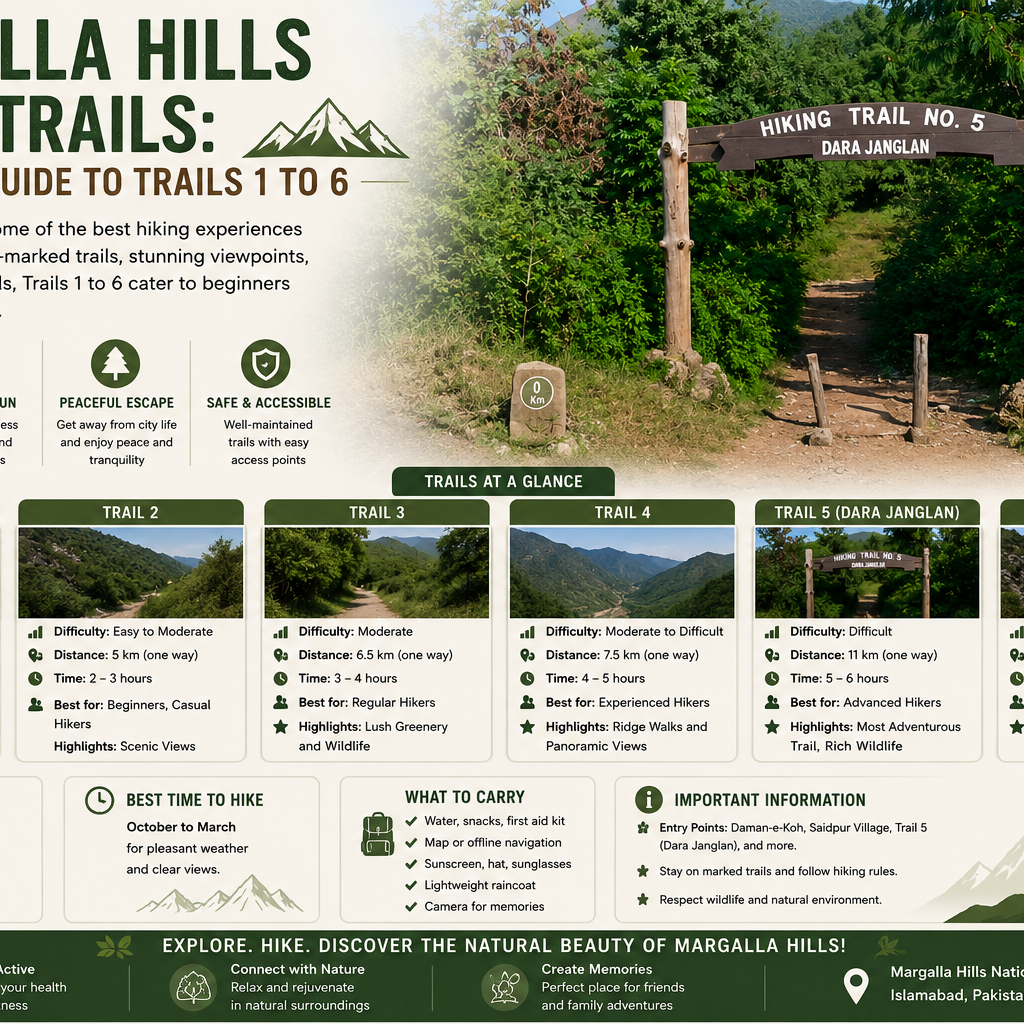
Margalla Hills Hiking Trails: A Complete Guide to Trails 1 to 6
The Margalla Hills rise along the northern edge of Islamabad and threading through them is a network of hiking trails that has made the capital one of the best cities in the country for walking and climbing. Numbered Trail 1 through Trail 6, these routes climb from the foothills through pine forest to ridgelines and viewpoints, offering everything from gentle family walks to steep, demanding climbs. For many residents, the trails are a regular part of life, a natural outdoor gym right on the city's doorstep.
This guide explains the Margalla Hills trail network, walks through each of the main trails and covers what you need to know before setting out. Written for anyone getting to know Islamabad, it is both a practical hiking guide and a look at one of the features that makes the capital so distinctive.
Margalla Hills trail network
The Margalla Hills form the green northern boundary of Islamabad, part of the outermost foothills of the Himalayas. They stretch roughly 30 kilometres east to west along the edge of the capital and they are protected within the Margalla Hills National Park, established in 1980. The elevation climbs from around 685 metres at the foothills to over 1,600 metres at the highest ridges which means a single hike can pass through different forest zones.
What makes the hills so accessible is the network of marked trails. The main routes are numbered Trail 1 through Trail 6, each starting from a different point along the base of the hills and offering a distinct character, length and level of difficulty. Most of the trailheads sit within a short drive of the central sectors, reachable in under 20 minutes which is what allows so many residents to hike regularly.
The trails wind through dense chir pine forest, scrubland and rocky outcrops, climbing towards viewpoints and, in several cases, up to the Pir Sohawa ridgeline. Along the way, hikers pass through a rich natural habitat, home to monkeys, deer, wild boar and hundreds of bird species. The park is a genuine conservation area rather than a manicured reserve which gives the trails their wild, natural feel.
This combination of accessibility and natural beauty is why the Margalla Hills trails are so loved. They offer a real escape into nature within minutes of the city and they suit every level, from families with children to serious hikers training for the mountains further north.
Quick answer: The Margalla Hills hiking trails are a network of marked routes, numbered Trail 1 to Trail 6, climbing through the hills along the northern edge of Islamabad. Set within the Margalla Hills National Park, they range from easy family walks to steep climbs, most starting within a short drive of the central sectors.
Trail 1 and Trail 2
Trail 1 begins in the hills behind Sectors E 8 and E 9, on the western side of the network. It is a demanding route that climbs up towards the Pir Sohawa road, taking around two hours of intense hiking to reach the top. The effort is rewarded with sweeping views and for those who commit to the climb, it offers a real workout. Because it is less central than some of the other trails, it tends to be quieter.
Trail 2 is at the other end of the difficulty scale and it is one of the most family friendly routes in the network. It starts near the Islamabad Zoo area at the base of the hills and leads up to the Daman e Koh viewpoint, taking around an hour or a little more. Because Daman e Koh has facilities such as food stalls, tea and a playground, Trail 2 is a popular choice for those who want a shorter walk with a rewarding destination. From Daman e Koh, it is possible to continue upward towards the Cactus Ridge for a longer hike. This makes Trail 2 the easiest way to reach the well known viewpoint on foot, suitable for people of most ages and fitness levels.
Together, these two trails show the range of the network, from a steep, demanding climb to a gentle family walk, both within the same hills.
Trail 3: the classic route
Trail 3 is the oldest and most famous hiking trail in the Margalla Hills and the one most Islamabad hikers return to across the seasons. It starts on Margalla Road in Sector F 6, in a central and easily reached location which is part of why it is so popular.
The trail climbs through dense chir pine forest up towards the Pir Sohawa ridgeline. It takes more than half an hour of moderate to steep hiking to reach a viewpoint, where the city opens up below, with Rawal Lake visible in the distance on clear days. From the middle of the trail, it takes around an hour on foot to reach the top near the Pir Sohawa road, from where hikers can continue to the restaurants at the summit. In total, it is roughly a one and a half hour walk to the top.
Trail 3 is well known for its upkeep. It is properly marked, with several rest areas and benches along the way and a parking area at the start. This good maintenance, combined with its central location and rewarding views, makes it the most popular route in the network and a favourite for both regular hikers and visitors. Many experienced hikers consider it the best overall trail in Islamabad for its balance of scenery, challenge and accessibility. The descent is on a different line from the ascent, with loose gravel and steep rocky sections that need care on the way down.
Trail 4 and Trail 5
Trail 4 is the quietest of the central trails, starting from Margalla Road in Sector F 7. It is narrower than Trail 3 and takes a different path at first, ascending through mixed scrub and forest before entering denser pine higher up. Its gradient is more consistent and its terrain less rocky than Trail 3, giving it an easier, steadier rhythm over its length. Importantly, Trail 4 also serves as a connector, linking Trail 3 and Trail 5 at certain points, so hikers can switch between routes. On a weekday morning it can feel almost empty, offering a more solitary experience. The trail also passes near the memorial to the Airblue crash, a site of remembrance in the hills.
Trail 5 is one of the most popular and scenic routes and it is often recommended for beginners as well as regular hikers. It begins at the northern end of Margalla Road in Sector F 5, near a visitor and nature area with a parking lot, plant nursery, educational centre, picnic area and camping site. The trail is known for starting with the rare sound of water and it climbs through forest up towards the top of the Pir Sohawa road. The full route takes around two and a half to three and a half hours to the top, though shorter sections make it accessible for gentler walks. Trails 3 and 5 run parallel for part of the way and are linked by Trail 4, allowing hikers to combine them. The facilities at the trailhead and its scenic quality make Trail 5 a favourite for many.
Trail 6 and beyond
Trail 6 is one of the more demanding and less used routes in the network, partly because its entrance is not widely known. It begins behind the Faisal Mosque in Sector E 7, near a tree planting project area and follows a marked path up towards the top terminal of the Pir Sohawa road. The trail is known for featuring a mountain bike track and a birdwatching point, adding to its appeal for those seeking a quieter, nature focused route. Its more demanding nature and remote feel make it rewarding for experienced hikers.
Beyond the six numbered trails, the Margalla Hills offer longer and more challenging routes for those wanting more. Some trails lead deep into the hills to villages and valleys, offering views of both Rawal Lake and, in places, lakes further afield. The most demanding routes climb all the way up towards Murree, connecting the Margalla Hills to the higher hills beyond, on long treks that take many hours and are used by hikers training for the northern mountains. These longer routes are for experienced walkers with proper preparation and often have no return path, so transport back needs to be arranged.
For most visitors and residents, though, the numbered trails offer more than enough variety, from a short family walk to a full day's climb, all within the national park on the edge of the city.
Safety and what to bring
Hiking in the Margalla Hills is generally safe and hugely popular but the hills are a genuine natural environment, so some preparation matters. The most important rule is to stay on the marked trails. This keeps hikers from getting lost, reduces the chance of surprising wildlife and protects the natural habitat.
The hills are home to wildlife including monkeys, wild boar and, rarely, leopards. It is always advisable to view any animal from afar without disturbing them or feeding them. There may be occasions when trails will be closed due to security concerns, such as the presence of leopards, thus it is important to inquire about that.
As far as the equipment to carry, one should make sure to wear comfortable clothes and walking shoes with good grip due to the loose rocks along the way. Carrying plenty of water is important, as most trails have no water sources along the way and snacks help on the longer routes. Weather appropriate gear matters too, since the hills can be hot in summer and cool higher up.
A few practical points help. Mobile signal on the upper sections of most trails is unreliable, so it is wise to arrange any pick up time before starting the climb. It is best not to hike alone and to let someone know your route and expected return. Early mornings, especially on weekends, are the best time to find parking at the popular trailheads which fill quickly. Most trails are free to access. The cooler months, from around October to March, are the most comfortable time for hiking and early mornings offer the clearest views and the coolest conditions.
Quick answer: Stay on marked trails, carry plenty of water and wear good walking shoes with grip. Observe wildlife from a distance and never feed animals. Avoid hiking alone, check for trail closures, arrange return transport before climbing since signal is unreliable and arrive early for parking. The cooler months and early mornings are best.
Why the Margalla trails matter to Islamabad
Beyond their role for hikers, the Margalla Hills trails are part of what makes Islamabad distinctive. The city was deliberately planned around its hills, preserving them as a green boundary rather than building over them and the trail network makes that green space genuinely usable for residents.
The ready access to nature, with real hiking trails within 20 minutes of the city centre, is a rare quality in a capital. It is one of the reasons Islamabad is often called one of the greenest and most beautiful cities in the region. The hills give residents an easy escape into nature, a place to exercise and a source of the fresh air and scenery that define the capital.
This natural setting shapes the appeal of the areas near the hills. The prestigious northern sectors of Islamabad, such as the E and F series, sit closest to the trailheads and their access to the hills and the trails adds to their desirability. For anyone drawn to an active, outdoor lifestyle with nature on the doorstep, the sectors near the Margalla Hills offer a setting few cities can match and the trail network is one of the features that defines this part of the capital.
Frequently asked questions
How many hiking trails are there in the Margalla Hills? The main network has six numbered trails, Trail 1 through Trail 6, each starting from a different point along the base of the hills. Beyond these, there are longer and more challenging routes leading deeper into the hills and up towards Murree.
Which is the best Margalla Hills trail for beginners? Trail 2 which leads to the Daman e Koh viewpoint, is one of the easiest and most family friendly, taking around an hour. Trail 5 is also often recommended for beginners because it has scenic route and good facilities at the trailhead.
Which is the most popular trail? Trail 3, starting on Margalla Road in Sector F 6, is the oldest and most popular route. It is well marked and maintained, with rest areas and parking and many consider it the best overall trail for its balance of scenery, challenge and accessibility.
Are the Margalla Hills trails safe? The trails are generally safe and heavily used. You should stay on marked paths, carrying water, not hiking alone and observing wildlife from a distance are important. Trails are occasionally closed for safety, such as reported leopard activity, so it is worth checking before setting out.
What should I bring for a hike? Comfortable clothing, good walking shoes with grip, plenty of water and snacks for longer routes. Weather appropriate gear is useful and since mobile signal is unreliable on the upper sections, arrange any return transport before starting the climb.
When is the best time to hike in the Margalla Hills? The cooler months, from around October to March, are the most comfortable. Early mornings offer the coolest conditions, the clearest views and the best chance of finding parking at the popular trailheads which fill quickly on weekends.
The Margalla Hills hiking trails are one of Islamabad's greatest natural assets, a network of routes that puts real hiking within minutes of the city. From the gentle family walk of Trail 2 to the classic climb of Trail 3 and the demanding heights of Trail 6, the trails offer something for every level, all within the protected national park on the northern edge of the capital.
For those getting to know Islamabad, the trails capture what sets the city apart: a modern capital planned around its hills, where nature is preserved and made accessible rather than built over. This ready escape into the hills shapes the character and appeal of the northern part of the capital and adds to the desirability of the sectors closest to the trailheads. Whether you hike the Margalla Hills for the exercise, the views, the wildlife or simply the fresh air and quiet, the trail network remains one of the essential features of Islamabad and a large part of why the capital is considered one of the most beautiful cities in the country.